
From point A to point B
City's multimodal draft plan imagines accessible, connected community
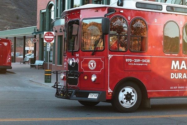
The trolley servicing Main Avenue takes off from the Transit Center on Tuesday evening. The city has struggled in recent years to make the Multimodal and Transportation budget sustainable. In 2015, they started charging $1 per ride as a way to increase revenues. But it's not enough. This year's ideas to fill the funding gap include raising parking tickets fine and bringing a sales tax in- crease to voters. /Photo by Jennaye Derge
It’s actually meant for a seventh-grader. The city’s recently updated Multi Modal Transportation Master Plan is full of ideas and potential projects that create a vision of Durango, according to Director of Transportation and Sustainability Amber Blake, where a seventh-grader, no matter where he or she lives or is headed, can get around town independently.
This vision was part of the original master plan, adopted in 2012 after three years of work and 75 public meetings. The lat- est version is more of a refinement, Blake said, with more than 20 meetings held during the year-long process to update it.
Blake and her team attempted to add the community’s input into the draft. She said if someone doesn’t see their ideas listed, send her an email so they can add it to the final.
They’ll continue to take comments until the end of October, incorporating those into the completed master plan which heads to the City Council in December for a vote. The hope is to update the plan every five years, making sure it doesn’t get stagnant or out of date.
“I think it’s really important the plan stays current and fresh,” Blake said.
In all, more than 50 projects have been completed since the 2012 plan was approved.
One currently under way is the Roosa Avenue Connectivity Project, which includes sidewalk improvements, bringing the area into compliance with the Americans with Disabilities Act, or ADA, and improving transit stops along the riverfront from El Paso Street to Highway 160.
Three completed projects are the Needham Connect Project, the East 2nd Avenue and East 15th Street Connectivity Project, and the West 24th Street Bridge and Brookside Park Connectivity Project.
The Needham project included adding sidewalks, ramps and other safety features around the elementary school. Sidewalks were also added in the East 2nd and 15th Street Connectivity Project, along with bike lanes, crossing signals and a three-lane configuration where the train crosses 15th Street. As a result of the Brookside endeavor, the park now has a new parking lot and ADA access to the nearby transit stop.
“It feels like we’re making a difference in the community,” Blake said.
All the projects are important, she added, but it comes down to funding.
Currently, the multimodal transportation system and Durango Transit have three primary funding sources: federal and state funds, which make up about 50 percent of the department’s operating revenue; local funds, which in- clude parking fees, lodgers’ taxes, sales taxes and other sources; and contracts and contributions, like donations from the Business Improvement District and contracts with Fort Lewis College to cover student transit.
All these sources, though, don’t bring in enough to make the yearly operating budget sustainable. At the start of 2015, the city began charging $1 for a trolley ride in an attempt to increase revenues. But it’s not enough.
This year, the city is looking at other ways to fill the gap, like raising the cost of parking tickets. They’ve even discussed bringing a sales tax proposal to voters.
Moving forward with projects in the draft plan, though, isn’t dependent on whether or not the city finds a way to make the transit budget sustainable because the funding for each project doesn’t come from that budget.
Some projects are funded by the Colorado Department of Transportation, like a resurfacing project on North Main, which will add bike lanes and other elements to the northern strip.
The draft plan divides the city into seven zones, like North Main Avenue or Bodo Park, attempting to tackle problems neighborhood by neighborhood while still keeping an eye on the overall goals of connectivity, accessibility and mobility. It also makes the 98-page document easier to navigate.
Each zone has a list of specific problems, or deficiencies, and a list of solutions, or proposed improvements.
One zone, referred to in the plan as “the heart of Durango,” covers historic downtown and the Camino del Rio corridor, running across the Central Business District from 5th to 14th streets and Camino del Rio to East 3rd Avenue.
A key issue for this area is how Camino is, in many ways, a barrier between the Animas River Trail and downtown. Pedestrians and cyclists using the flashing light crosswalks near 13th or 7th streets call it a game of chicken.
The draft plan identifies the need for “a safe crossing of Camino del Rio.” One idea is to create an underpass allowing someone to move safely and easily from downtown to the River Trail.
It’s not the first time the city has floated the idea. The city considered it in 2009, but a feasibility study found the “cost, engineering constraints, and lack of support by neigh- boring business owners made the proposal largely infeasible,” according to the plan.
Seven years later, the idea is again gaining traction, and city officials are planning a second feasibility study.
One of the residents supporting the idea of an underpass is Rick Feeney, a local architect who has been involved with historic preservation in Durango since the early 1980s. He not only serves as the chair of the Design Review Board, he had a hand in the restoration of several local landmarks, including the old Powerhouse.
Feeney said he remembers sitting at Guido’s on the corner of 12th and Main with his friend Paul Wilbert, a luminary and cycling advocate in the Durango community who passed away in March.
The two could see the tourists hit the intersection and turnaround, believing that’s all there was to see.
An underpass flowing from the Central Business District, under Camino and toward the River Trail and Powerhouse, could help those same tourists discover Durango’s other gems and even stay in town a little longer.
Feeney called the Durango & Silverton Narrow Gauge Railroad “the engine of the
economy.” Without a connection to the city’s other stand-out feature, the Animas River Trail, “it’s like there’s no caboose,” he said.
Seeing the connection made and the vision realized wouldn’t just be a solution to Durango’s disconnect in this zone, it would be a way to honor Wilbert.
Another zone with specific problem areas covers the neighborhoods around Riverview Elementary School, running from 32nd Street to Holly Avenue and Main Avenue all the way to County Road 250.
One of the biggest barriers to connectivity in this area is the web of streets surrounding the school. There’s no direct route to the most commonly used spot.
One suggestion is a trail connector to provide access across between 30th Street and Holly Avenue, an area under served by pedestrian or bicycle facilities.
Heading south to Bodo Park, there’s a missing link between the hotels on the west side of Highway 550 and the east side, which includes the River Trail and Durango Mall.
“It would be desirable to connect the existing hotels with sidewalk to the Bodo Drive area,” the draft plan reads, “where hotel pa- trons could walk along frontage sidewalks to Office Depot and cross Camino del Rio at the signal to access the (Animas River Trail).”
The plan contains all types of projects – complicated, simple, long and short-term.
Even grand visions like River Street, which would extend 10th Street as a pedestrian area from Narrow Gauge Avenue to an underpass at Camino del Rio as part of a future Town Plaza redevelopment. Or an idea to build a gondola connecting the Horse Gulch Medical Campus on 8th and East 3rd avenues to Three Springs.
Blake said because the projects discussed in the draft plan are in their infancy, it’s unlikely anything would be controversial.
What’s important is including all the ideas, identifying disconnects and brainstorming solutions.
“This is really stage one or phase one of getting a project completed,” Blake said.
Get the draft at www.getarounddurango.com, send comments to amber.blake@durangogov.org.
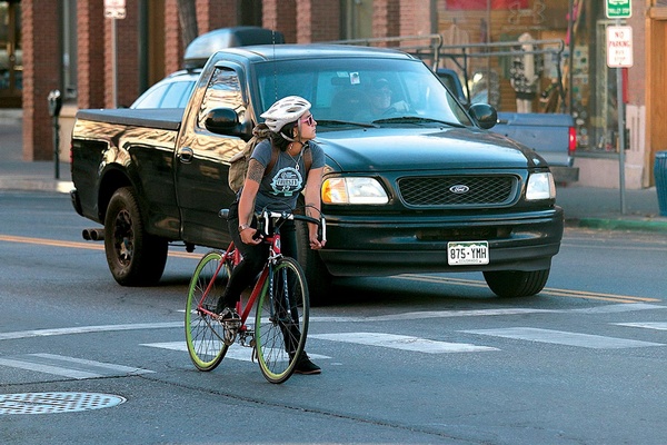
The city's Multi Modal Transportation Master Plan divides the city into seven zones, like Bodo Park or downtown, attempting to tackle specific problems neigh- borhood by neighborhood./Photo by Jennaye Derge