
Geologic tick
How a prehistoric landslide in San Juans can help communities deal with climate change
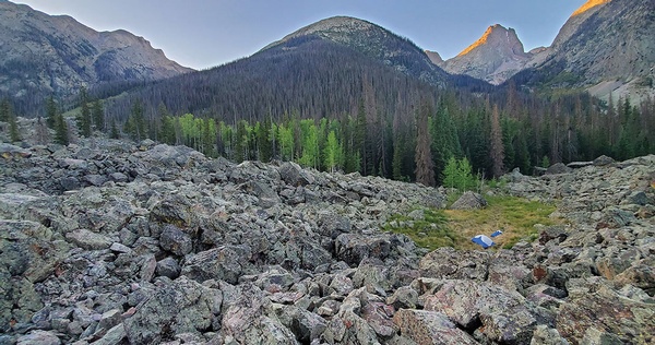
A 14,000-year-old landslide deposited massive boulders in Elk Creek./ Photo by Jonathan Harvey
A newly documented landslide in the San Juan Mountains that dates back to the last Ice Age might help answer one of climate change’s most pressing questions: do retreating glaciers increase the frequency and intensity of landslides?
Around 2018, Jonathan Harvey, Chair & Associate Professor of Geosciences at Fort Lewis College, was perusing recently released topography maps – as geologists are wont to do – enhanced by Lidar technology, which uses radar to map out the Earth.
While scanning through the Weminuche Wilderness, Harvey noticed some strange happenings in the upper half of Elk Creek, a tributary of the Animas River a few miles south of Silverton (which also runs alongside the Colorado/Continental Divide trails).
“I started getting curious about it,” Harvey said. “It became clear there had been an enormous landslide in the past that dramatically changed the landscape. But it appeared no one had mapped it. It was an unexplored geological feature.”
So, like all good scientists dealing with the universe’s unknowns, Harvey hiked into the basin to see it in person along with an FLC student. Now, three years later, the “Elk Creek Landslide Project” is showing promising returns.
For one, Harvey was happy enough to unlock a geological mystery in our own back yard. But also, Harvey’s research may help inform communities around the world that are also dealing with increased landslides as glaciers melt and retreat due to climate change. And it couldn’t have come at a better time.
“This is a hazard that has not been given much attention, but with these fast-receding glaciers, it’s a hazard increasing in potential,” Anna Liljedahl, an Alaska-based hydrologist with the Woods Hole Research Center, said.
A stark contrast
Elk Creek is a relatively remote area. The only access to the trail is hiking down from Molas Pass, across the Animas River and up into the basin. Or, maybe, if you ask really, really nicely, the Durango & Silverton Narrow Gauge Railroad will drop you off.
But that’s not to say the place isn’t frequently visited. Hikers use the route as a leg of the Colorado Trail as well as the Continental Divide Trail. And, many people take the Elk Creek Trail to get into Vestal Basin.
For the first part of the trail, from the confluence with the Animas, you are in a steep, tight canyon. Then, about 3 miles in, the canyon abruptly opens up into a wide valley bottom. Just as eye-catching, however, is what’s on the valley floor: thousands of large boulders, some the size of houses.
“It’s a stark contrast,” Harvey said. “It’s this huge sea of boulders for about a mile, unlike anything else in the San Juans that I’ve seen.”
During the first field trips in the summer of 2019, Harvey and a student spent a couple days mapping the slide, measuring its scale and taking samples so they could pinpoint the exact time the event happened. Continued study in 2020 sought to reconstruct the valley before the landslide came crashing down.
“Boulder fields are obviously common,” Harvey said. “But to have an entire valley bottom filled with boulders struck me as unique, and I wanted to know why and how it happened.”
Glacial retreat
Through modeling, Harvey was able to estimate the size of the landslide at about 50 million cubic meters of rock (a washing machine, for example, is one cubic meter, “so imagine 50 million washing machines tumbling down all at once,” Harvey said). The sheer size of the event, he said, likely would have blocked Elk Creek and created a dammed lake in the valley.
To pin down the timeframe, Harvey sampled five boulders to see how long they’d been sitting there, through cosmogenic nuclide dating, which basically measures how long a rock has been exposed to the sun (think of it as “cosmic sunburn,” Harvey joked).
All five rock samples came back with the same results: about 14,000 years. Which makes sense, Harvey said. At the peak of the last Ice Age in North America, about 21,500 years ago, the San Juan Mountains were covered in glaciers all the way down to Durango (oh, the ski terrain that once was).
But, around 17,000 years ago, those glaciers started to melt and retreat. According to a 2017 study published by The Geological Society of America, upper Elk Creek was ice-free by about 15,000 years ago. Silverton was clear by around 14,000 years ago, and the last gasps of ice in the San Juan ice cap may have hung on as late as 12,000 years ago (around Highland Mary Lakes).
“There is some fuzziness to those dates, but based on the set of ages, the study area in Elk Creek should have been either ice-free or well on its way there at the time of the landslide,” Harvey said.
Connecting the dots: glaciers melted, destabilizing the mountain slopes, causing the landslide.
“It seems like a case where, as soon as the ice retreated, the valley wall was too unstable and collapsed in a single major event,” Harvey said. “But it is an interesting phenomena that we’re still learning about.”
A triggering factor?
It’s true – whether retreating glaciers cause more landslides is a hot topic in the geology world, especially in places dealing with the impacts of climate change in real time, like Alaska, Norway and Greenland.
“It’s a controversial issue,” Jeff Coe, a U.S. Geological Survey landslide geologist, said. “It’s hard for me to argue there’s not an impact from glacial retreat, but in the same breadth, what’s happening in the mountains is not well known.”
Glacial retreat is a natural process but has been accelerated by human-caused climate change. Of about 1,700 glaciers in North America included in a University of Ottawa study, nearly 85% shrunk between 2000 and 2020. A report in April 2021, too, showed the world’s glaciers are melting faster than ever previously documented.
As a result, the concern in these communities is clear: will the disappearance of glaciers result in more massive, potentially catastrophic landslides?
“We know landslides also happen when ice is there,” Coe said. “So the question is, does the frequency increase when you take away the ice? Is that a triggering factor? That topic is controversial.”
Disaster in the making
The issue is of particular concern in places like Alaska, where, if a slope were to totally break away, it could fall into the ocean and cause a tsunami.
“The retreat of ice is leading to greater instability, and we don’t really know when we could see a sudden collapse cause a disastrous situation,” Bret Higman, a geologist who works for the Alaska-based nonprofit Ground Truth, said. “It’s pretty scary.”
Such events are not unprecedented. In 2015, a landslide at the Taan Fjord in Alaska triggered a 600 foot wave. And in 2017, a landslide set off a wave more than 300 feet high in Greenland that destroyed a fishing village and killed four people. One area of major concern today is the Barry Arm glacier in Alaska, frequented by tourists and fishing boats, where some 500 million cubic meters of mass could fail at any moment.
Long-term, Higman worries this could be a dominant issue in the years to come. In the meantime, the scientific community is working to better understand the issue and possibly create an early warning system. The USGS, for instance, has invested around $8 million to the cause.
“We have a lot to learn,” Liljedahl said. “Academics need to meet the real world.”
Learning from the past
So how does a 14,000-year-old landslide in Southwest Colorado help communities dealing with the issue now?
“It’s like history in general,” Liljedahl said. “It’s important to be aware of what happened in the past to understand what might be happening in the near future.”
The USGS’s Coe, too, said with enough case studies that prove a link between retreating glaciers and increased landslides, it could put the controversial question to bed. “There’s definitely circumstantial evidence (of the link), but we just don’t have good scientific data to say it more firmly,” he said.
Geological research is experiencing a sea change, Harvey said, as scientists increasingly study less about how the Earth was made and instead about how it’s changing. But the more researchers look back in the geologic record, the more it can help us understand our changing world.
“The more we can learn about prehistoric events, the more we can understand the hazard when it happens now and in the future,” Harvey said. “All this has been so exciting for us. It felt rare to be able to find such a huge event that wasn’t named, described or measured in any way, right here in our back yard.”