
How low will it go?
States try to agree on new flow formula while Lake Powell continues to shrink
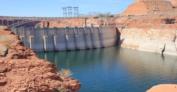
A downstream view of Glen Canyon Dam. After years of overly optimistic outlooks on Colorado River flows and over-allocation, states that rely on it are taking a sober look at a new formula to determine how much water each state gets./Courtesy photo
The words “urgency” and “immediate action” were used by Trump administration officials Aug. 15 in releasing the U.S. Bureau of Reclamation 24-month outlook for the Colorado River Basin.
The study sees a high probability of Lake Powell water levels falling to within 48 feet of the minimum power pool by January. That elevation, 3,490 feet above sea level, is the reservoir’s lowest level at which hydroelectricity can be produced. That has not happened since Powell began filling in 1966.
“This underscores the importance of immediate action to secure the future of the Colorado River,” David Palumbo, acting BuRec commissioner, said.
Scott Cameron, acting Department of Interior assistant secretary for water and science, had similar words of warning. “As the basin prepares for the transition to post-2026 operating guidelines, the urgency for the seven Colorado River Basin states to reach a consensus has never been clearer,” he said. “We cannot afford to delay.”
The announcement cited “unprecedented drought” but made no mention of climate change. This seems to be a theme.
Cameron, at the University of Colorado’s annual water seminar in Boulder in June, talked for 24 minutes without once mentioning climate change. He even answered a question about climate change without using the phrase. He did seem to acknowledge it, saying that in the “real world” there is less water than before, “and that is probably not going to change a whole bunch.”
But, might the situation be even worse than what the BuRec has projected?
A bias of optimism
On Aug. 14, a day before the release of the 24-month report, John Fleck and others posted an analysis on Fleck’s Inkstain that warned the study would likely be overly optimistic.
The problem, explained Fleck and his co-authors, is that the “assumptions underlying the study do not fully capture the climate change-driven aridification of the Colorado River Basin.”
The bureau uses a 30-year average in predicting what lies ahead. However, using hydrology dating back to the 1990s no longer provides the same usefulness. The climate is changing too fast.
Paul Milley, formerly of the U.S. Geologic Survey, noted this problem in a 2008 paper, “Stationarity is Dead: Whither Water Management.”
In that paper, Milley and his co-authors argued that human-induced climate change was altering the means and extremes of precipitation, evapotranspiration and rates of runoff. As such, using old models to guide water management no longer worked as well.
In their posting at Inkstain, Fleck and his coauthors noted that a year ago, the BuRec’s 24-month study found that the “most probable” level for Powell would be 3,593 at the end of July 2025. But it was 38 feet lower than that after a so-so winter and an early, warm spring.
This, they said, illustrated the bias toward optimism by the agency. That bias had been detailed in a 2022 study by a team led by Jian Wang, of the Utah State Center for Colorado River Studies.
The bureau also issues maximum and minimum probable scenarios. Fleck and his team contend that the bureau’s minimum probable scenario has become the most valuable in providing a reliable indicator of future flows.
This past winter was mediocre, near average snowfall in some basins but among the worst in the San Juans. Spring was warm in many places, and rains in July were almost entirely absent.
The preliminary estimated inflow into Powell for April-July was 41% of average from 1991-2020, according to the bureau’s “most-probable” outlook. But in July, inflows slipped to 12% of the 30-year average.
Might fortunes soon be reversed? Not likely anytime soon, said Fleck and his team, noting this summer’s weak monsoon coupled with the seasonal outlook by the National Oceanic and Atmospheric Administration, which points to a warmer and drier than average fall.
“It’s a good bet that this trend will continue at least through winter,” they wrote.
As it stands, levels in Lake Mead, downstream from Powell, will necessitate cuts in the lower basin as required by several agreements reached between 2007-19. Arizona is to see an 18% cut and Nevada a 7% cut in annual apportionments. Mexico is to get 5% less than its annual allotment. In acre-feet, that’s 412,000 for Arizona; 21,000 for Nevada; and 80,000 for Mexico.
A new agreement
The big story continues to be what agreements the seven basin states can achieve in recognition of reduced flows. “Megadrought” and “aridification” are words now common in Colorado River discussions. A study published recently in Nature identifies new ways that the warming climate has altered the hydrology of Colorado and other southwestern states (see: “Why rain and snow skip the Southwest.”)
In 2018, an agreement among the states was reached regarding how to deal with drought. It was universally recognized as an interim agreement, with a final decision to be reached in advance of a 2026 deadline. That deadline is now close at hand.
“The health of the Colorado River system and the livelihoods that depend on it are relying on our ability to collaborate effectively and craft forward-thinking solutions that prioritize conservation, efficiency and resilience,” Cameron, Interior’s undersecretary, said in the Aug. 15 announcement.
In June, Cameron called on basin states to submit a preliminary agreement in November and a final seven-state proposal in February 2026. The plan would be to reach a final decision in the summer of 2026 with implementation beginning October 2026.
Non-government organizations issued statements also calling for the states to find a way forward.
“This is not just a crisis. It’s also a call to action to use remaining time wisely to replace our current, reactive, emergency-based management framework with new, long-term solutions,” John Berggren, regional policy manager for Western Resource Advocates, said. “We can’t litigate our way out – we must collaborate.”
For many months, reports suggested that the four-upper basin states – Wyoming, Colorado, Utah and New Mexico – and the three lower-basin states – Arizona, Nevada and California – remained far apart. A story June 27 in the Las Vegas Review Journal described the meetings as “tense” and “deadlocked.”
The Colorado River Compact of 1922 specified that the upper basin states “will not cause the flow of the river at Lee Ferry to be depleted” below an aggregate of 75 million acre-feet for any 10 consecutive years. But what if the river fails to deliver that much water? Upper-basin states have delivered that volume so far, mostly because Wyoming, in particular, has not developed what was expected 100 years ago.
Those who had originally gathered in 1922 to negotiate the compact had understood drought, but only as a temporary thing. They had no extensive long-term perspective – and chose to ignore what evidence was at hand, according to a 2019 book by Fleck and Kuhn, “Science be Dammed: How Ignoring Inconvenient Science Drained the Colorado River.”
The beef of Colorado’s and other upper-basin states has been that the two big dams on the river provided certainty for the lower-basin states to get water. However, the headwaters states have no certainty. They must live with what Mother Nature provides. They have balked at cutting water use to provide certainty for downstream states. They want the risk shared.
Natural flow proposal
In June came word of what may have been a breakthrough: the “natural flow proposal.” As explained by Tom Buschatzke, the director of Arizona Water Resources, to the Arizona Republic on June 18, the idea is to focus less on who gets what and more on what the river can realistically provide.
“We do have to recognize what the hydrologic risks are to us,” he said, “and we have to find an equitable way to share those risks.”
That idea being discussed would employ a rolling three-year average of the natural flow of the river. “Natural” is defined as the volume if there were no diversions and impoundments.
Buschatzke – a frequent visitor at the Colorado River forum sponsored by the University of Colorado each June – pointed out that the goal would be to spread the pain equitably, not equally. The lower basin would need more water than the upper basin, which has still to develop all the water it was allocated in the 1922 compact.
“It is not 50-50,” he told represents at the June 17 meeting. “I won’t try to speculate on what the number might be.”
A few weeks later, John Entsminger, Nevada’s representative in interstate talks, similarly was vague about details. “It’s not something where I can tell you what the score is in the third inning: the baseball game is still being played,” he told the Las Vegas Review-Journal.
“Everybody’s pretty much accepted that we’ve got to come up with a new formula,” Mark Squillace, an environmental law professor at the University of Colorado told the Las Vegas newspaper. “The devil’s in the details.”
Mitchell, Colorado’s representative on the Upper Colorado River Commission (and its acting chair), told the Review-Journal that the 2007 guidelines that provide the management map of the river’s operations are not sustainable because “the water is just not there. It’s not in storage, and it’s not in the river.”
In a June story in Politico, Mitchell described the natural flows idea as a math problem. The concept under discussion is that Powell would release a certain percentage of the average of the last few years of natural flows, as measured at Lee Ferry, she said.
Politico described a more complex challenge: The premise of sharing the river based on how much water would travel downstream without dams or diversions or other human interventions is a complex mathematical problem, rife with pitfalls and technical issues. Furthermore, this idea would likely take several years to implement. As such, it would not immediately impact levels in the reservoir. As for the minimum power pool, some 16 electrical utilities in Colorado get power from the dam. But the greatest value of Glen Canyon is that if the Western grid has a blackout, it can be restarted with hydropower from the dam.
And too, the role of Congress
As administrator of the two big dams in the basin and several smaller ones, the federal government must figure out how to manage them consistently with the agreements among the states. It is also the formal administrator among the lower-basin states.
At the conference in Boulder, Cameron clearly said the federal government wants the states to figure out the solution. However, he also said that if the states cannot come to an agreement, the federal government, as the administrator, has authority to set policy.
And finally, he mentioned that the whole package may need to go to Congress, as was the case with the Colorado River Compact. It was approved in 1929. (Arizona refused to endorse the compact until much later).
Allen Best is a Colorado journalist who publishes an e-magazine called Big Pivots. Reach him at: allen.best@comcast.net.